The Administrative-Territorial Boundaries Available for a Multiscalar Analysis of EU Port Cities
Abstract
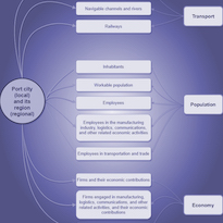
Using various administrative-territorial boundaries, inhabitants, and businesses as nodes, port cities in the European Union (EU) could be analyzed on multiple scales using a network method that takes into account the most important criteria (transport, population, and economy) for measuring the urban and port functions. The possible beneficiaries of such a methodology are policymakers who can aid municipalities in resolving problems in port cities. Thus, this study aimed to pinpoint existing port city policy domains that can be impacted by such a methodology and make corresponding recommendations. The policy domains identified in most port cities (port, port-city, and transportation policies) were matched with the three criteria established by the methodology. Study findings indicate that the proposed network methodological approach can impact urban and spatial policies' internal and external configuration. Also, it can impact their related policy instruments because they should be selected in light of the port city's current state.
Key words: a network methodological approach, urban and spatial policies, port-city policy, port policy, transport policy
Downloads

Downloads
Published
How to Cite
Issue
Section
License
Copyright (c) 2023 Simona Dolana

This work is licensed under a Creative Commons Attribution 4.0 International License.
The authors keep their rights upon their work, although they transfer, in a non-exclusive way, the rights of exploitation (reproduction, publication, distribution, public dissemination and presentation) to the Journal. The authors are, therefore, free to enter additional, separate contracts for the non-exclusive distribution of the version of the work published in the Journal (for instance, by hosting in an institutional repository or publication in a book), provided credit is given that the work was initially published in this journal. The works are published under a Creative Commons Attribution 4.0 (CC BY 4.0) license.


